
 Continue with onX Maps
 Continue with Facebook


 Particularly Special Place


 Intermediate

 Intermediate
Land Manager: USFS - George Washington & Jefferson National Forests
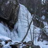
 Apple Orchard Falls - Cornelius Creek
7.8 mi 12.5 km • 2,069' Up 630.78 m Up • 2,067' Down 629.99 m Down
 Buchanan, VA
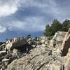
Devils Marbleyard Out and Back
Buchanan, VA
Devils Marbleyard Out and Back
2.8 mi 4.5 km • 778' Up 237.17 m Up • 778' Down 237.09 m Down
Glasgow, VA
 Sulphur Springs Price Mountain Loop
4.9 mi 7.9 km • 1,282' Up 390.69 m Up • 1,268' Down 386.41 m Down
Virginia's Triple Crown Loop
34.8 mi 55.9 km • 6,774' Up 2064.63 m Up • 6,778' Down 2065.99 m Down
Salem, VA
Rocky Row
7.5 mi 12.0 km • 1,873' Up 570.83 m Up • 1,873' Down 570.8 m Down
Dragon's Tooth
4.8 mi 7.7 km • 1,162' Up 354.24 m Up • 1,174' Down 357.81 m Down
New Castle, VA


0 Comments