Use onX Backcountry to explore the terrain in 3D, view recent satellite imagery, and more.
Now available in onX Backcountry Mobile apps!
For more information see this post.
Check the self-service pay station near the entrance for fees and regulations.
Description
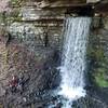
This trail starts at the intersection of Brock Creek #40. This trail is primitive dirt doubletrack; from Brock Creek #40 it heads south, descending to Brock Creek Lake before making a sharp turn back west, winding upward to reconnect with Brock Creek #40.
This is primarily considered an OHV trail but is also open to motos, mountain bikes, horses, and foot traffic. Please stay alert while using this trail and be respectful of all users.
We use cookies to improve your browsing experience, to show you
personalized content, and for statistical purposes. By continuing
to navigate our website, you accept our use of cookies. Read our
Privacy Policy to learn more.

 Continue with onX Maps
 Continue with Facebook


 Particularly Special Place


 Intermediate


0 Comments