Dogs Off-leash

Features
Fall Colors · River/Creek · Waterfall

Open year round.
Description
This classic trail from the 1930's is the most direct (i.e. steepest) assent up Mt Ascutney. The bottom half follows a brook, with one tricky water crossing and plenty of water for dogs most of the way.
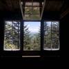
About 20 minutes up from the start, hikers will come to Gerry's Falls, a little rest spot with a beautiful waterfall. It goes by the old stone lean-to shelter, which is worth seeing, especially since it has a spring for fresh drinking water. There are a few views, but not many.
The trail is interesting with flora in the summer and fall foliage. It's a significant hike in snow, but I know a couple 70-year-olds that made it, so it is definitely doable!
Flora & Fauna
My favorite on this trail are the painted Trillium, between early May and late June, the later in spring, the further up they'll be. There's also some poison ivy further up to watch out for.
Contacts
Shared By:
Stew Stryker

 Continue with onX Maps
 Continue with Facebook


 Particularly Special Place


 Intermediate/Difficult

 4.3 (4)


0 Comments