
 Continue with onX Maps
 Continue with Facebook


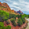
 Particularly Special Place


 Intermediate
Intermediate
Intermediate
 Intermediate
Land Manager: BLM Utah - St. George Field Office
 Mount Kinesava Out-and-Back
7.8 mi 12.5 km • 3,179' Up 968.84 m Up • 3,179' Down 968.83 m Down
 Springdale, UT
 The Subway Hike
7.8 mi 12.5 km • 1,911' Up 582.36 m Up • 1,911' Down 582.43 m Down
Springdale, UT
 Pa'rus Trail out and back
3.3 mi 5.4 km • 103' Up 31.53 m Up • 104' Down 31.57 m Down
 Northgate Peaks Out and Back
4.4 mi 7.1 km • 183' Up 55.66 m Up • 181' Down 55.27 m Down
 Many Pools Hike
2.2 mi 3.6 km • 572' Up 174.27 m Up • 572' Down 174.28 m Down
Kolob Arch via La Verkin Creek
14.1 mi 22.7 km • 1,431' Up 436.03 m Up • 1,432' Down 436.33 m Down
 Toquerv…, UT


0 Comments