Dogs Leashed

Features
Birding · River/Creek · Views

Texas State Park - follow all user rules.
Description
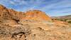
Starting at the north end at the Mac Dick Pavilion Trailhead starts a short, meandering climb that turns into a quick descent before crossing the creek. Then it has short, little climbs and undulations into short descents crossing dry creeks that progress into a contour that hugs the canyon wall with ups and downs. There is nothing that is overly technical, but there are some blind corners that do require attention.
The contours spill out onto a grassy plain that heads down to the creek where you can cross into the Hackberry Campground and hook up with the
Kiowa Trail or end up in the Givens, Spicer & Lowry Trail Trailhead.
Or, you can continue on and start some switchbacks that bring you back up to the canyon wall where you'll find more contour hiking with a few short ups and downs. There is another switchback waiting, and then a little more contouring trail and you'll end up at
Comanche Trail Mid where you can continue on with a left turn or you can head to the Chinaberry Parking with a right turn.
This is an amazingly fun trail, but yet still challenging. It can be done north to south or south to north and it can be split into two sections depending on where you start and has three access points.
Contacts
Shared By:
Glenn Ladehoff
with improvements
by Joan Pendleton
and 1 other

 Continue with onX Maps
 Continue with Facebook


 Particularly Special Place


 Intermediate/Difficult


 All Clear


0 Comments