Dogs Unknown

Features
Swimming · Views
Overview
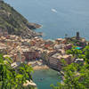
This hike enables you to get away from the noise of Porto Venere and enjoy unique views of the city and castle. Highlights include passing multiple WWII era bunkers and gun emplacements, a castle, and beach access for swimming. A short ferry ride to/from Porto Venere harbor is also a fun addition.
Need to Know
Be sure to check the ferry schedule. Alternatively, you can enjoy a meal at the fancy restaurant on the island and take their private water taxi. There are limited to no public restrooms on the island.
Description
Start with a short ferry ride from Porto Venere across to Isola Palmaria and get off at the first stop. Check the ferry schedule in advance for both your arrival and departure as it generally only runs once per hour. Note that there are many trails on the island, and, generally, they are well signed.
Upon exiting the ferry, turn right and continue along the coast past the beach cafe to the start of the trail Here the trail starts out steeply and climbs quickly from the beach up to the top of the island, mostly shaded by trees. An occasional hand line is available but using them didn't seem necessary in dry conditions.
Great views abound as you ascend looking back to Porto Venere and out to the sea. As you continue on the hike, you'll come across numerous WWII bunkers and lookout points that you can investigate. Near the southern tip of the island, you can see the ruins of an old marble quarrying operation.
On the southeast side of the island, you hike along the coast and come to a nice swimming beach at Pozzale that may have food services in high season (June-August). Head inland from Pozzale and climb a steep set of stairs to regain the higher trail. Then continue on the easy trail to the second ferry point, and the hike's end.
History & Background
Fortifications (medieval, renaissance, WWII), old marble quarries, etc.
Shared By:
Vikram Sahney

 Continue with onX Maps
 Continue with Facebook


 Particularly Special Place


 Intermediate


0 Comments