
 Continue with onX Maps
 Continue with Facebook


 Particularly Special Place


 Easy
Easy
Easy
Easy
 Easy
Easy
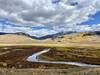
 East River Trail Out and Back
4.5 mi 7.2 km • 281' Up 85.67 m Up • 281' Down 85.74 m Down

 Crested…, CO
 The Caves Loop Hike
4.5 mi 7.3 km • 970' Up 295.77 m Up • 976' Down 297.62 m Down
 Mt. Crested Butte to Aspen via East Maroon Pass
29.9 mi 48.1 km • 3,199' Up 975.06 m Up • 4,640' Down 1414.25 m Down
Crested…, CO
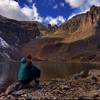
Cathedral Lake Trail
5.5 mi 8.8 km • 2,098' Up 639.41 m Up • 2,098' Down 639.32 m Down
Aspen, CO
American Lake
6.5 mi 10.4 km • 1,972' Up 601.06 m Up • 1,972' Down 600.99 m Down
Aspen, CO
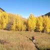
 Summerville Trail Out and Back
21.7 mi 34.9 km • 5,279' Up 1609.14 m Up • 5,277' Down 1608.58 m Down


0 Comments