Dogs Unknown

Features
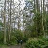
Birding · Views · Wildflowers
Description
The following are suggestions for outings along the Leanganook Track. For further details on this trail, refer to the Goldfields Track walking guide or
click here.
This trail is used by bushwalkers, runners and mountain bikers (limited access).
This trail can be done in segments. Refer to the website for their recommendations. The following are suggestions for a hike:
Castlemaine Trail Station to Chewton: Follow the signs from the Castlemaine Train Station up over the hill with the monument at the east end of the main street of town. Once down the other side of the hill, the trail follows Forest Creek along a nice flat gravel trail to Chewton - this is recommended as a beginner hike. This could be done as an out and back trail.
Over Mount Alexander: Start at McQuillans Road, Harcourt and hike up and over Mount Alexander to the Harcourt-Sutton Grange Road, carefully following the track signposts. This is trail is singletrack the whole way. The trail is rocky and steep in parts.
Coliban Water Race: The Goldfield Track picks up the Coliban Water Race from Harcourt - Sutton Grange Road to Sandhurst Reservoir in Bendigo. There are a number of locations where roads cross the water race, and hikers can pick up the trail. This part of the track follows the water race and is slightly sloping; however, there is a hill just south and just north along the trail where it crosses North Harcourt Road. Most of this trail is along a well-formed four wheel drive track.
Sandhurst Rerservoir into Bendigo: The trail here is through the bush and is a combination of singletrack, bush tracks and four wheel drive tracks. The trail is rocky and hilly and travels through old mining areas.
Shared By:
Jacqui Knee

 Continue with onX Maps
 Continue with Facebook


 Particularly Special Place


 Intermediate

 4.5 (2)


1 Comment