
 Continue with onX Maps
 Continue with Facebook


 Particularly Special Place


 Difficult
Difficult
Difficult
 Difficult
Land Manager: USFS - Caribou & Targhee National Forests Office
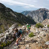
 Paintbrush Divide
19.6 mi 31.6 km • 3,932' Up 1198.51 m Up • 3,932' Down 1198.49 m Down
 Jackson, WY
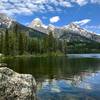
 Hermitage Point
10.2 mi 16.4 km • 438' Up 133.55 m Up • 430' Down 131 m Down
 Yellows…, WY
 Bradley - Taggart
6.2 mi 9.9 km • 656' Up 199.81 m Up • 660' Down 201.26 m Down
Jackson, WY
Death Canyon & Static Peak Divide to Teton Canyon
19.6 mi 31.6 km • 4,383' Up 1335.98 m Up • 4,231' Down 1289.52 m Down
Moose W…, WY
Terraced Falls
3.9 mi 6.2 km • 361' Up 110.13 m Up • 362' Down 110.24 m Down
Yellows…, WY
Union Falls
16.6 mi 26.7 km • 1,740' Up 530.3 m Up • 1,740' Down 530.31 m Down
Yellows…, WY


0 Comments