
 Continue with onX Maps
 Continue with Facebook


 Particularly Special Place


 Intermediate
Intermediate
Intermediate
 Intermediate
Land Manager: USFS - Black Hills National Forest Office
 Horsethief Lake Loop
11.1 mi 17.9 km • 1,672' Up 509.77 m Up • 1,672' Down 509.72 m Down

 Custer, SD
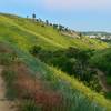
 Far East / Founders Valley Loop
2.9 mi 4.7 km • 327' Up 99.58 m Up • 327' Down 99.79 m Down
Rapid City, SD
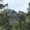
Black Elk Peak Loop
7.9 mi 12.7 km • 1,357' Up 413.68 m Up • 1,357' Down 413.67 m Down
Custer, SD
Sanctuary/ Centennial/ Highland Creek Loop
11.2 mi 18.0 km • 839' Up 255.58 m Up • 839' Down 255.78 m Down
Hot Spr…, SD
Custer Peak
8.3 mi 13.3 km • 1,014' Up 309.07 m Up • 1,014' Down 309.15 m Down
Hell Canyon Trail
5.4 mi 8.7 km • 606' Up 184.71 m Up • 629' Down 191.69 m Down
Custer, SD


 All Clear


0 Comments