Dogs Leashed

Features
Spring · Views · Wildflowers
Description
This trail is suggested as a one-way trek either by using two cars (one at each end), or as a drop-off and pick-up at the end.
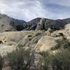
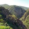
Start this trail by joining the paved road heading west. The road turns from paved to dirt in about three miles, just after passing Sulphur Mountain. The trail offers beautiful panoramic views of Ojai Valley and the surrounding mountain ranges, and in the springtime is a wonderful place to enjoy wildflowers. Though this is a long trail (12.8 miles), the majority of it is a gentle downhill from east to west (as mapped), making for a nice day hike.
Keep in mind that much of this trail passes along private property, so be sure to stay on the trail.
Thanks to John McKinney, The Trailmaster, for sharing this trail description. To learn more about trails in California, check out his guides at
The Trailmaster Store.
Flora & Fauna
Wildlife that may be spotted includes deer, coyotes, bobcats, foxes, rattlesnakes, and tarantulas. For the birders, red-tailed hawks and roadrunners are frequently seen here. Cattle from the local ranches frequent the hillsides and occasionally overtake the road, so use caution when hiking around blind corners.
In the springtime, wildflowers are prominent; it is common to see lupine, yellow mustard, and California poppies across the landscape.
Contacts
Shared By:
John McKinney

 Continue with onX Maps
 Continue with Facebook


 Particularly Special Place


 Intermediate


0 Comments