
 Continue with onX Maps
 Continue with Facebook


 Particularly Special Place


 Intermediate

 Intermediate
Land Manager: USFS - Chugach National Forest Office
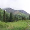
 Byron Glacier Trail
1.9 mi 3.0 km • 207' Up 63 m Up • 207' Down 62.98 m Down
 Girdwood, AK
Portage Glacier (Winter)
Girdwood, AK
Portage Glacier (Winter)
6.1 mi 9.8 km • 820' Up 249.87 m Up • 818' Down 249.41 m Down
Girdwood, AK
 Portage Pass Trail
4.4 mi 7.2 km • 934' Up 284.68 m Up • 933' Down 284.33 m Down
Girdwood, AK
Crescent Creek Trail
12.8 mi 20.6 km • 1,138' Up 346.78 m Up • 1,138' Down 346.75 m Down
Bear Creek, AK


0 Comments