Use onX Backcountry to explore the terrain in 3D, view recent satellite imagery, and more.
Now available in onX Backcountry Mobile apps!
For more information see this post.
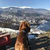
“A great, mixed terrain trail to show some of the best Vitosha has to offer.
”
From Cherni Vrah, follow the blue marked trail towards Zlatina Mostove. The trail begins steeply then becomes more gradual with mixed rocks. It flattens out as you travel through Torfeno Braniste Reserve. The trail then descends steeply through a small ski resort then picks up a well-maintained gravel trail as it comes down into Zlatina Mostove.
We use cookies to improve your browsing experience, to show you
personalized content, and for statistical purposes. By continuing
to navigate our website, you accept our use of cookies. Read our
Privacy Policy to learn more.

 Continue with onX Maps
 Continue with Facebook


 Particularly Special Place


 Intermediate/Difficult


0 Comments