
 Continue with onX Maps
 Continue with Facebook


 Particularly Special Place


 Intermediate/Difficult
Intermediate/Difficult
Intermediate/Difficult
 Intermediate/Difficult
Land Manager: USFS - Los Padres National Forest Office
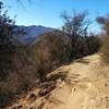
 Gridley Trail to Nordhoff Peak
14.3 mi 23.1 km • 3,328' Up 1014.42 m Up • 3,327' Down 1014.22 m Down

 Ojai, CA
 Valley View Loop
6.9 mi 11.1 km • 1,288' Up 392.68 m Up • 1,295' Down 394.66 m Down
Rice Canyon and Wills Canyon Trails Loop
4.5 mi 7.3 km • 434' Up 132.41 m Up • 434' Down 132.27 m Down
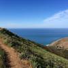
 Ray Miller at Pt. Mugu
5.5 mi 8.8 km • 964' Up 293.88 m Up • 963' Down 293.67 m Down
Camarillo, CA
 Harbor Seal Preserve
2.8 mi 4.5 km • 48' Up 14.74 m Up • 48' Down 14.75 m Down
Los Robles to Angel Vista Point
7.3 mi 11.8 km • 957' Up 291.73 m Up • 967' Down 294.62 m Down
Thousan…, CA


0 Comments