
 Continue with onX Maps
 Continue with Facebook


 Particularly Special Place


 Intermediate
Intermediate
Intermediate
 Intermediate
Land Manager: BLM Utah - Monticello Field Office
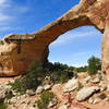
 Owachomo Bridge Out and Back
0.5 mi 0.8 km • 172' Up 52.46 m Up • 173' Down 52.61 m Down
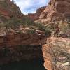
 Moon House Ruins
4.6 mi 7.4 km • 497' Up 151.59 m Up • 497' Down 151.56 m Down
Blanding, UT
Natural Bridges National Monument Full Loop
8.5 mi 13.6 km • 752' Up 229.3 m Up • 731' Down 222.83 m Down
 Blanding, UT
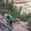
 Fish and Owl Canyon Loop Route
17.1 mi 27.5 km • 1,992' Up 607.16 m Up • 1,995' Down 608.12 m Down
Blanding, UT
 House on Fire Ruins
2.0 mi 3.2 km • 52' Up 15.81 m Up • 52' Down 15.77 m Down
Blanding, UT
Hammond Canyon to Posey Canyon
10.5 mi 16.9 km • 2,482' Up 756.51 m Up • 2,186' Down 666.3 m Down
Blanding, UT


0 Comments