
 Continue with onX Maps
 Continue with Facebook


 Particularly Special Place


 Difficult
Difficult
Difficult
 Difficult
Local Club: San Gabriel Mountains Trailbuilders (SGMTB)
Land Manager: USFS - Angeles National Forest Office
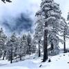
 San Antonio Falls - Sierra Club Ski Hut - Devil's Backbone
10.8 mi 17.3 km • 3,810' Up 1161.35 m Up • 3,813' Down 1162.11 m Down

 Mount B…, CA
 Timber Mountain
8.8 mi 14.1 km • 3,296' Up 1004.74 m Up • 3,296' Down 1004.63 m Down
San Ant…, CA
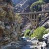
Bridge to Nowhere - East Fork Trail #8W13
9.8 mi 15.8 km • 814' Up 248.01 m Up • 814' Down 248.01 m Down
La Verne, CA
 Etiwanda Falls
3.3 mi 5.3 km • 747' Up 227.83 m Up • 751' Down 228.79 m Down
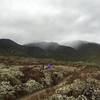
Crystal Lake to Mt. Islip Loop
9.9 mi 15.9 km • 2,687' Up 819.03 m Up • 2,690' Down 819.88 m Down
Mount Williamson
4.4 mi 7.0 km • 1,517' Up 462.44 m Up • 1,516' Down 462.16 m Down
Wrightwood, CA


 Bad / Closed


0 Comments