
 Continue with onX Maps
 Continue with Facebook


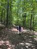
 Particularly Special Place


 Difficult
Difficult
Difficult
 Difficult
Local Club: Roanoke Outside
Land Manager: Roanoke Parks and Recreation
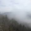
 Carvins Cove Route
12.4 mi 19.9 km • 1,271' Up 387.28 m Up • 1,270' Down 387.12 m Down

 Hollins, VA
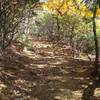
 Dragon's Tooth
4.8 mi 7.7 km • 1,162' Up 354.24 m Up • 1,174' Down 357.81 m Down
New Castle, VA
 Mill Mountain Park Loop
7.3 mi 11.7 km • 1,293' Up 393.98 m Up • 1,291' Down 393.55 m Down
Roanoke, VA
Kelly Knob Out and Back
7.9 mi 12.7 km • 1,752' Up 534.1 m Up • 1,752' Down 533.93 m Down
Blacksburg, VA
Flat Top Mountain
5.2 mi 8.4 km • 1,410' Up 429.91 m Up • 1,411' Down 430.08 m Down
Buchanan, VA
Bottoms Creek Gorge
4.2 mi 6.8 km • 558' Up 170.02 m Up • 557' Down 169.76 m Down


0 Comments