Hiking Project Logo

A relatively flat, well-maintained, shaded, crusher trail with several vistas of the Mon River.


Your Rating: Rating Rating Rating Rating Rating      Clear Rating
Your Difficulty:
Your Favorites: Add To-Do · Your List
Zoom in to see details
Map Key

5.2

Miles

8.3

KM

Point to Point

807' 246 m

High

771' 235 m

Low

80' 24 m

Up

58' 18 m

Down

1%

Avg Grade (0°)

3%

Max Grade (2°)

Dogs Leashed

Features Fall Colors · River/Creek · Spring · Views · Wildflowers

Description

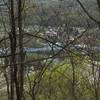
The trail begins in a marina, and then winds along the Mon River, sitting about 20 feet above the water where a railroad used to be. There are several small hills, but no steep grades. A halfway point takes you through Rices Landing where there is another access point with a parking lot and port-a-pot. At the southern end, there is no access point, and it is just a turn-around to go back.

Shared By:

Bobby Bonser

Trail Ratings

  4.5 from 2 votes

#1

in Millsboro

#9691

Overall
  4.5 from 2 votes
5 Star
50%
4 Star
50%
3 Star
0%
2 Star
0%
1 Star
0%
Trail Rankings

#1

in Millsboro

#171

in Pennsylvania

#9,691

Overall
4 Views Last Month
178 Since Jan 9, 2017
Easy Easy

100%
0%
0%
0%
0%
0%

0 Comments

Weather


Current Trail Conditions

Unknown
Add Your Check-In

Check-Ins

Jul 20, 2019
Jenna Amtower
10mi
Apr 7, 2019
Perry Arlia
nice, easy trail for anyone. 10.4mi — 4h 44m
Apr 2, 2018
John Jackson
3.2mi
Oct 7, 2017
John Jackson
Saw a friendly garter snake, lots of walnuts, hickory nuts, monkey balls, and acorns. 3.1mi
Welcome

Join the Community

Create your FREE account today!
Already have an account? Login to close this notice.

Get Started