This trail travels between a trailhead low on Mount Diablo State Park's South Gate Road (no parking) and the summit of Mount Diablo via the south face of the mountain. Parts of the trail are singletrack and parts are dirt road.
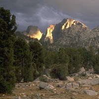
Leaving the South Gate Road Trailhead, this trail climbs up canyon into the Rock City area, interesting for its geology and for its bouldering opportunities, and meets
Wall Point Road coming in from the west. Despite the various trail names you'll encounter here (maps and trail signs may not agree with each other), there are several possible "Summit Trail" routes from here going uphill, and all will take you eventually to the shoulder of South Gate Road, so you can be creative.
Once you have passed the Ridge View Trail and crossed South Gate Road, and are climbing with the road to your left, you'll see the summit ahead of you, and views will begin to open up in the other directions. This trail's route is now more direct, and sometimes quite steep. You'll be encountering areas that burned during the Morgan Fire of September 2013, and in these areas vegetation will be quite different (in the spring, wildflower blooms can be excellent). Along the way this trail crosses Summit Road twice. Then, approaching the summit area, this trail contours just below Summit Road, providing fine views to the south.
At Devils Elbow, this trail grazes the outside edge of a hairpin turn on Summit Road (
North Peak Trail departs from here going east) and switches back just above it. Soon this trail reaches the summit area, with a parking area to the left. To the right, you'll see Mary Bowerman Trail (aka
Fire Interpretive Trail, referring to the Morgan Fire) veer right, but instead this trail crosses the one-way vehicle road leading toward the summit and continues into a thin "island" of rocky outcrops inside the one-way vehicle road loop.
Continue on this trail to the actual summit, where you'll find a restroom building as well as the summit building with an observation deck on the roof. From there, you enjoy expansive views in all directions.

 Continue with onX Maps
 Sign in with Facebook


 Particularly Special Place


 Difficult


0 Comments