
 Continue with onX Maps
 Continue with Facebook


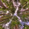
 Particularly Special Place


 Difficult
Difficult
Difficult
 Difficult
Land Manager: California State Parks - Tamalpais State Park
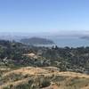
 Panoramic Loop
4.5 mi 7.3 km • 943' Up 287.4 m Up • 941' Down 286.79 m Down

 Tamalpa…, CA
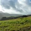
Ring Mountain Loop
Tamalpa…, CA
Ring Mountain Loop
2.9 mi 4.6 km • 584' Up 177.96 m Up • 584' Down 178.07 m Down
Corte M…, CA
Tennessee Valley: Ridge Trail to Coast Loop
5.4 mi 8.7 km • 924' Up 281.5 m Up • 936' Down 285.36 m Down
Tamalpa…, CA
Golden Gate Bridge Overlook Out-and-Back
5.3 mi 8.5 km • 1,000' Up 304.86 m Up • 999' Down 304.44 m Down
Sausalito, CA
 South Headlands Loop (Coast-Miwok-Alta)
7.8 mi 12.6 km • 1,243' Up 378.86 m Up • 1,239' Down 377.52 m Down
Sausalito, CA
 Miller/Knox Regional Shoreline Kid Friendly Loop
3.0 mi 4.9 km • 68' Up 20.63 m Up • 68' Down 20.7 m Down


0 Comments