
 Continue with onX Maps
 Continue with Facebook


 Particularly Special Place


 Intermediate/Difficult
Intermediate/Difficult
Intermediate/Difficult
 Intermediate/Difficult
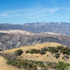
 ACLCT Loop
8.8 mi 14.1 km • 3,231' Up 984.75 m Up • 3,230' Down 984.61 m Down
 Mission…, CA
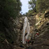
 Inspiration Point and Seven Falls
3.8 mi 6.2 km • 916' Up 279.27 m Up • 915' Down 278.77 m Down
 Canyon Loop
4.4 mi 7.0 km • 1,257' Up 383.04 m Up • 1,271' Down 387.33 m Down
 Montecito, CA
Douglas Family Preserve Loop
Montecito, CA
Douglas Family Preserve Loop
1.6 mi 2.6 km • 160' Up 48.72 m Up • 160' Down 48.67 m Down
San Ysidro Falls
3.6 mi 5.8 km • 1,031' Up 314.18 m Up • 1,030' Down 314.02 m Down
 Harbor Seal Preserve
2.8 mi 4.5 km • 48' Up 14.74 m Up • 48' Down 14.75 m Down


0 Comments