
 Continue with onX Maps
 Continue with Facebook


 Particularly Special Place


 Easy
Easy

 Easy
Easy
Land Manager: NPS - Redwood
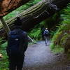
 Friendship Ridge Loop Hike
8.0 mi 12.9 km • 1,168' Up 355.87 m Up • 1,167' Down 355.68 m Down
 Westhav…, CA
Redwoods Splendor Loop
Westhav…, CA
Redwoods Splendor Loop
16.9 mi 27.3 km • 3,718' Up 1133.29 m Up • 3,708' Down 1130.34 m Down
Westhav…, CA
 Yurok Loop Trail
1.1 mi 1.8 km • 80' Up 24.28 m Up • 79' Down 24.01 m Down
 Damnation Creek Trail
3.7 mi 6.0 km • 1,215' Up 370.28 m Up • 1,200' Down 365.65 m Down
Bertsch…, CA
Emerald Ridge - Redwood Creek Loop
5.3 mi 8.6 km • 860' Up 262.21 m Up • 756' Down 230.56 m Down
Westhav…, CA
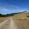
Lyons Ranch Trail
3.6 mi 5.8 km • 463' Up 140.98 m Up • 463' Down 141.06 m Down
Westhav…, CA


0 Comments