
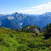
 Copper Ridge Loop
35.4 mi 57.1 km • 8,660' Up 2639.55 m Up • 8,658' Down 2638.84 m Down
 Peacefu…, WA
Church Mountain Trail
Peacefu…, WA
Church Mountain Trail
8.6 mi 13.9 km • 3,639' Up 1109.21 m Up • 3,640' Down 1109.39 m Down
 Peacefu…, WA
 Heliotrope Divide
5.4 mi 8.7 km • 1,636' Up 498.56 m Up • 1,635' Down 498.33 m Down
Peacefu…, WA
Elbow Lake - Bell Pass - Ridley Creek Loop
14.1 mi 22.7 km • 3,793' Up 1156.23 m Up • 3,788' Down 1154.73 m Down
Thornton Lakes
9.5 mi 15.4 km • 3,067' Up 934.74 m Up • 3,067' Down 934.92 m Down
Diablo, WA
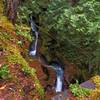
 Ladder Creek Falls
0.5 mi 0.8 km • 116' Up 35.42 m Up • 116' Down 35.31 m Down

 Continue with onX Maps
 Continue with Facebook


 Particularly Special Place


0 Comments