
 Continue with onX Maps
 Continue with Facebook


 Particularly Special Place


 Intermediate
Intermediate
Intermediate
 Intermediate
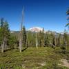
 Lassen Lakes Loop
11.8 mi 19.0 km • 1,424' Up 434.05 m Up • 1,434' Down 437.09 m Down


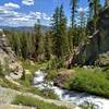
 Kings Creek Falls Out and Back
2.5 mi 4.1 km • 460' Up 140.33 m Up • 467' Down 142.49 m Down
Chester, CA
Hat Creek Spattercone Trail
1.8 mi 2.9 km • 253' Up 77.08 m Up • 253' Down 77.06 m Down
Burney, CA
 Bizz Johnson National Recreation Trail
26.3 mi 42.4 km • 295' Up 89.82 m Up • 1,349' Down 411.24 m Down
Westwood, CA


0 Comments