
 Continue with onX Maps
 Continue with Facebook


 Particularly Special Place


 Very Difficult
Very Difficult
Very Difficult
 Very Difficult
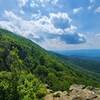
Land Manager: NPS - Shenandoah National Park
 Nicholson Hollow
11.6 mi 18.6 km • 2,092' Up 637.62 m Up • 2,093' Down 637.95 m Down

 AT/Passamaquoddy/Furnace Springs Loop
2.8 mi 4.5 km • 591' Up 180.22 m Up • 605' Down 184.28 m Down
 Whiteoak Canyon - Hawksbill Summit Loop
13.6 mi 21.8 km • 3,652' Up 1113.19 m Up • 3,649' Down 1112.08 m Down
 Stanley, VA
Neighbor Mountain - Jeremys Run Loop
Stanley, VA
Neighbor Mountain - Jeremys Run Loop
14.0 mi 22.5 km • 2,503' Up 762.95 m Up • 2,509' Down 764.82 m Down
Rose River Loop
3.8 mi 6.1 km • 796' Up 242.59 m Up • 797' Down 242.97 m Down
Stanley, VA
Dark Hollow Falls
1.7 mi 2.7 km • 495' Up 150.91 m Up • 495' Down 151.02 m Down
Stanley, VA


0 Comments