Land Manager: Maryland Department of Natural Resources
 Cool Spring Run to Loops
4.3 mi 6.9 km • 352' Up 107.44 m Up • 355' Down 108.2 m Down


 Clarksburg, MD
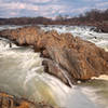
 Great Falls Overlooks Out and Back
3.8 mi 6.1 km • 45' Up 13.72 m Up • 45' Down 13.65 m Down


 Great F…, VA
 Timber Ridge/Tobacco Barn to Pine Grove Loop
5.4 mi 8.7 km • 483' Up 147.14 m Up • 481' Down 146.76 m Down


 Green V…, MD
 Lake Bernard Frank Loop
3.5 mi 5.7 km • 301' Up 91.76 m Up • 300' Down 91.3 m Down


 Rossmoor, MD
 Berma Road to Billy Goat Trail Section A
3.5 mi 5.7 km • 110' Up 33.53 m Up • 127' Down 38.57 m Down


 Potomac, MD
 Monocacy Battlefield - Thomas Farm
2.3 mi 3.7 km • 93' Up 28.38 m Up • 93' Down 28.44 m Down


 Balleng…, MD


0 Comments