
 Continue with onX Maps
 Continue with Facebook


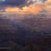
 Particularly Special Place


 Intermediate
Intermediate
Intermediate
 Intermediate
Land Manager: National Park Service - Grand Canyon National Park
 Bright Angel Trail Out-and-Back
16.0 mi 25.7 km • 4,366' Up 1330.9 m Up • 4,367' Down 1331.07 m Down
 Grand C…, AZ
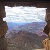
 Cape Royal Trail
0.9 mi 1.5 km • 32' Up 9.71 m Up • 32' Down 9.71 m Down
 Grand C…, AZ
 Uncle Jim Complete Loop
4.8 mi 7.8 km • 494' Up 150.7 m Up • 495' Down 150.91 m Down
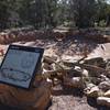
Tusayan Ruins Loop
0.2 mi 0.4 km • 30' Up 9.06 m Up • 30' Down 9.19 m Down
 Desert View Point
0.5 mi 0.7 km • 27' Up 8.35 m Up • 26' Down 7.99 m Down
Grand C…, AZ
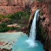
 Havasu Falls
19.1 mi 30.7 km • 2,346' Up 715.05 m Up • 2,346' Down 715.11 m Down
Grand C…, AZ


0 Comments