
 Continue with onX Maps
 Continue with Facebook


 Particularly Special Place


 Easy/Intermediate
Easy/Intermediate
Easy/Intermediate
 Easy/Intermediate
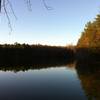
Land Manager: USFWS - Wheeler National Wildlife Refuge
 Blackwell Swamp Loop
7.8 mi 12.6 km • 75' Up 22.79 m Up • 74' Down 22.54 m Down
 Madison County Nature Trail
1.1 mi 1.8 km • 75' Up 22.95 m Up • 76' Down 23.25 m Down
 Jean Shorts Special
4.6 mi 7.5 km • 755' Up 230.21 m Up • 754' Down 229.93 m Down
 Owens C…, AL
 Big Cove to Duck Weed Basin Loop
4.5 mi 7.3 km • 17' Up 5.05 m Up • 17' Down 5.07 m Down
Old Railroad Bed to Alms House
1.7 mi 2.7 km • 177' Up 53.84 m Up • 190' Down 58.01 m Down
North Plateau Loop
1.9 mi 3.0 km • 79' Up 24.16 m Up • 81' Down 24.77 m Down


0 Comments