
 Continue with onX Maps
 Continue with Facebook


 Particularly Special Place


 Intermediate
Intermediate
Intermediate
 Intermediate
Land Manager: Dead Horse Point State Park
 Funnel Arch Hike
0.5 mi 0.9 km • 223' Up 68.08 m Up • 227' Down 69.24 m Down

 Moab Retreat: Day 1 Full Pint
13.8 mi 22.3 km • 1,830' Up 557.88 m Up • 1,833' Down 558.64 m Down
 Moab, UT
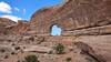
Jeep Arch / Gold Bar Arch Trail
Moab, UT
Jeep Arch / Gold Bar Arch Trail
3.8 mi 6.1 km • 918' Up 279.82 m Up • 923' Down 281.31 m Down
Moonflower Canyon
0.6 mi 1.0 km • 66' Up 20.04 m Up • 66' Down 19.98 m Down
Moab, UT
 Upheaval Dome Overlook Trail
1.4 mi 2.3 km • 278' Up 84.69 m Up • 278' Down 84.7 m Down
Mill Canyon Dinosaur Trail
1.9 mi 3.0 km • 90' Up 27.48 m Up • 91' Down 27.59 m Down
Moab, UT


0 Comments