
 Continue with onX Maps
 Continue with Facebook


 Particularly Special Place


 Easy/Intermediate

 Easy/Intermediate
Land Manager: National Park Service - Olympic National Park
 Boulder Lake - Happy Lake Ridge Loop
16.1 mi 26.0 km • 4,238' Up 1291.69 m Up • 4,247' Down 1294.54 m Down
 Mt. Muller
12.2 mi 19.7 km • 3,962' Up 1207.75 m Up • 3,946' Down 1202.81 m Down
 Forks, WA
 Humes Ranch Loop
6.0 mi 9.6 km • 688' Up 209.64 m Up • 694' Down 211.49 m Down
Heather Park Loop
11.8 mi 19.0 km • 4,730' Up 1441.72 m Up • 4,758' Down 1450.18 m Down
Port An…, WA
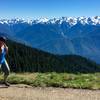
Hurricane Hill Nature Trail Out and Back
3.2 mi 5.2 km • 702' Up 214.1 m Up • 703' Down 214.3 m Down
Port An…, WA
Gray Wolf Loop
43.6 mi 70.1 km • 9,711' Up 2959.79 m Up • 9,718' Down 2962.1 m Down


 All Clear


0 Comments