
 Continue with onX Maps
 Continue with Facebook


 Particularly Special Place


 Easy/Intermediate


 Easy/Intermediate
Land Manager: Boulder County, CO - Parks and Open Space
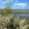
 Mesa Reservoir Loop
1.9 mi 3.1 km • 77' Up 23.34 m Up • 79' Down 24.23 m Down
 Coyote Run - Harper Lake - Davidson Mesa - Louisville Res
8.3 mi 13.3 km • 334' Up 101.69 m Up • 330' Down 100.71 m Down
Anne U. White Trail
3.3 mi 5.3 km • 444' Up 135.23 m Up • 444' Down 135.29 m Down
Boulder, CO
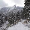
 Royal Arch Out and Back
3.4 mi 5.5 km • 1,252' Up 381.69 m Up • 1,251' Down 381.29 m Down
Boulder, CO
 Marshall Mesa to Spring Brook Loop
11.1 mi 17.9 km • 889' Up 271.11 m Up • 889' Down 271.02 m Down
Superior, CO
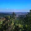
Flagstaff Summit Loop
2.4 mi 3.9 km • 346' Up 105.4 m Up • 337' Down 102.81 m Down
Boulder, CO


0 Comments