
 Continue with onX Maps
 Continue with Facebook


 Particularly Special Place


 Intermediate/Difficult
Intermediate/Difficult
Intermediate/Difficult
 Intermediate/Difficult
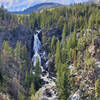
 Upper Fish Creek Falls
4.8 mi 7.7 km • 1,477' Up 450.32 m Up • 1,478' Down 450.39 m Down
 Steambo…, CO
 Panorama Trail
1.4 mi 2.3 km • 127' Up 38.79 m Up • 146' Down 44.4 m Down
 Steambo…, CO
Mad Creek Trail
Steambo…, CO
Mad Creek Trail
7.5 mi 12.1 km • 730' Up 222.5 m Up • 729' Down 222.1 m Down
Steambo…, CO
 Rabbit Ears Peak
5.4 mi 8.7 km • 832' Up 253.55 m Up • 832' Down 253.64 m Down
Rainbow Lake
8.5 mi 13.7 km • 1,376' Up 419.46 m Up • 1,376' Down 419.49 m Down
Walden, CO
Zirkel Circle
10.4 mi 16.8 km • 2,360' Up 719.41 m Up • 2,363' Down 720.25 m Down
Steambo…, CO


0 Comments