
 Continue with onX Maps


 Particularly Special Place


Rate Photo


Joan Pendleton
Sep 10, 2018
near Grande Cache,
AB
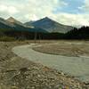
“The Smoky River spread out across gravel flats, making for a lower water level, and therefore, easier ford. Seen looking downstream (northwest) from the northeast river bank, at the alternate Smoky River crossing.”


 Great Divide Trail (GDT)


0 Comments