Continue with onX Maps
 Sign in with Facebook


 Particularly Special Place


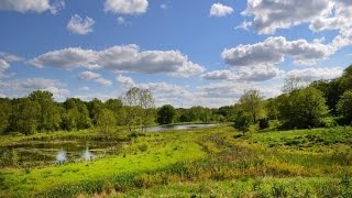
3M Wetlands
 MO
MO- …Northeast Missouri
- Columbia
- 3M Wetlands


Overview
Please find additional information on the site, which might be useful for potential users, or current users of the park/trail. como.gov/parksandrec/park/3…
3M Wetlands Hiking
- 1 Miles 2 Kilometers of Trail
- 0 Recommended Routes
- 1
Easy Trail

- 1
Intermediate Trail

- 0
Difficult Trails

Hiking Project is built by hikers like you. Share
what you know about this area!
Weather Averages
|
High
|
Low
|
Precip
|
Days w/
|
| J | F | M | A | M | J | J | A | S | O | N | D |
Trails in 3M Wetlands - 2
Hiking Project is built by hikers like you. Add Your Trails
0.6
mi
1.0
km
#13M Wetlands Connector
 Easy
Easy
Columbia, MO


|
Easy
|
Columbia, MO |
2
|
|
0.5
mi
0.8
km
#2Forum Katy Parkway Connector
 Intermediate
Columbia, MO
|
Intermediate
|
Columbia, MO |
2
|
Photos of 3M Wetlands - 8
Hiking Project is built by hikers like you. Add Your Photos