Continue with onX Maps
 Sign in with Facebook


Southeast Washington
 WA
WA- Southeast Washington


Gems in Southeast Washington - 2
Hiking Project is built by hikers like you. Add Your Gems


Recommended Routes in Southeast Washington - 15
Hiking Project is built by hikers like you. Add Your Recommended Routes


 Intermediate
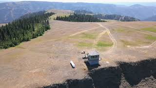
Oregon Butte Lookout
5.8 mi 9.3 km • 1,443' Up 439.8 m Up • 1,442' Down 439.67 m Down
 Dayton, WA
 Intermediate
White Bluffs North Slope Trail
6.0 mi 9.6 km • 534' Up 162.77 m Up • 533' Down 162.48 m Down
Basin City, WA
 Intermediate
Table Rock Fire Lookout
1.1 mi 1.8 km • 184' Up 56.23 m Up • 184' Down 56.04 m Down
Walla W…, WA
 Intermediate
Wildflower Loop Route
3.8 mi 6.2 km • 408' Up 124.38 m Up • 407' Down 124.19 m Down
Tieton, WA
 Intermediate
Badger Mountain - Trailhead Park Loop
3.3 mi 5.3 km • 810' Up 246.78 m Up • 807' Down 245.96 m Down

 Easy/Intermediate
Ancient Lakes Loop Trail
4.7 mi 7.5 km • 222' Up 67.58 m Up • 222' Down 67.56 m Down

 Intermediate/Difficult
Rocky Top
6.3 mi 10.1 km • 1,090' Up 332.37 m Up • 1,089' Down 331.99 m Down
 Gleed, WA


Southeast Washington Hiking
- 489 Miles 787 Kilometers of Trail
- 15 Recommended Routes
- 2 Gems

- 108
Easy Trails

- 67
Intermediate Trails

- 47
Difficult Trails

Areas Within Southeast Washington
Weather Averages
|
High
|
Low
|
Precip
|
Days w/
|
| J | F | M | A | M | J | J | A | S | O | N | D |
Trails in Southeast Washington - 207
Hiking Project is built by hikers like you. Add Your Trails
1.0
mi
1.6
km
#1Wildflower Trail
 Easy
Easy
Tieton, WA
|
Easy
|
Tieton, WA |
1
|
|
|
1.8
mi
2.9
km
#2Gunsmoke
Intermediate
Ellensburg, WA
|
Intermediate
|
Ellensburg, WA |
1
|
|
|
0.3
mi
0.5
km
#3Rooks Park
Easy
Walla Walla East, WA
|
Easy
|
Walla Walla East, WA |
1
|
|
|
1.0
mi
1.6
km
#4Rail Road Trail
Easy
Kennewick, WA
|
Easy
|
Kennewick, WA |
1
|
|
7.7
mi
12.4
km
#5Bear Creek Trail
 Difficult
Pomeroy, WA
|
Difficult
|
Pomeroy, WA |
1
|
|
|
1.6
mi
2.5
km
#6Upper Cowiche Mountain West
Intermediate
Tieton, WA
|
Intermediate
|
Tieton, WA |
1
|
|
|
0.9
mi
1.5
km
#7Cougar Bait
Intermediate
Ellensburg, WA
|
Intermediate
|
Ellensburg, WA |
1
|
|
|
0.9
mi
1.4
km
#8Butte Climb
Difficult
Asotin, WA
|
Difficult
|
Asotin, WA |
1
|
|
|
1.8
mi
3.0
km
#9Mountain View
Intermediate
Asotin, WA
|
Intermediate
|
Asotin, WA |
1
|
|
|
0.7
mi
1.1
km
#10Rum Punch
Intermediate
Ellensburg, WA
|
Intermediate
|
Ellensburg, WA |
1
|
Photos of Southeast Washington - 180
Hiking Project is built by hikers like you. Add Your Photos