
 Continue with onX Maps
 Continue with Facebook


 Particularly Special Place


 Difficult
Difficult
Difficult
 Difficult
Land Manager: USFS - Gallatin National Forest Office
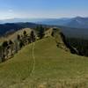
 Wilson Peak
12.5 mi 20.1 km • 4,164' Up 1269.08 m Up • 4,163' Down 1268.88 m Down

 Big Sky, MT
 Lava Lake Trail
5.7 mi 9.1 km • 1,581' Up 481.85 m Up • 1,579' Down 481.15 m Down
Big Sky, MT
Sky Rim - West
19.4 mi 31.3 km • 4,313' Up 1314.66 m Up • 4,313' Down 1314.57 m Down
Gardiner, MT
Montana Trail 406 Section 12: Cinnamon Lodge to Emigrant
49.1 mi 79.0 km • 8,732' Up 2661.65 m Up • 10,339' Down 3151.18 m Down
Big Sky, MT
 Storm Castle
4.9 mi 7.9 km • 1,819' Up 554.53 m Up • 1,819' Down 554.43 m Down
Four Co…, MT
Triple Tree Trail
5.6 mi 9.1 km • 906' Up 276.15 m Up • 906' Down 276.15 m Down
Bozeman, MT


0 Comments