Dogs Unknown

Features
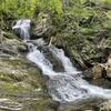
Views · Wildlife
Need to Know
This place is frequented by vandals and partiers... please avoid this area around dusk.
Description
This trail follows blue plastic circles. This trail starts off the west end of the parking area, off Dalton Avenue. It ascends the hill, northeasterly then northward. It reaches Junction 6 and continues straight, coinciding with
Red Trail.
When the trails split,
Blue Trail turns left. It ascends past
White Trail to a pass atop the ridge. Here, there is a short spur of stone steps (on the right). While the stone stairs bring you to a small summit, I don't think that this is the highest point on the ridge. After passing between the rocky peaks, the trail turns left. It parallels the rocky ridgeline until it reaches the view at The Boulders. Here, there are great views (minus the town).
Flora & Fauna
Flora: Privet, Japanese Knotweed, Sugar Maple, Oak, Multiflora Rose, Black Raspberry.
Contacts
Shared By:
David Smith

 Continue with onX Maps
 Continue with Facebook


 Particularly Special Place


 Intermediate


0 Comments