
 Continue with onX Maps
 Continue with Facebook


 Particularly Special Place


 Intermediate
Intermediate
Intermediate
 Intermediate
Land Manager: USFS - White Mountain National Forest Office
 Diana's Bath Out and Back
1.1 mi 1.8 km • 83' Up 25.41 m Up • 85' Down 25.82 m Down

 North C…, NH
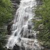
 Arethusa Falls Out and Back
2.9 mi 4.7 km • 868' Up 264.68 m Up • 869' Down 264.78 m Down
Black Cap Trail
2.5 mi 4.0 km • 590' Up 179.92 m Up • 589' Down 179.53 m Down
North C…, NH
Lower Ammonoosuc River Falls Trail
2.4 mi 3.9 km • 102' Up 31.07 m Up • 102' Down 31.04 m Down
 Franconia Ridge Loop
8.3 mi 13.4 km • 3,566' Up 1086.87 m Up • 3,564' Down 1086.35 m Down
Lincoln, NH
Pemi Loop
30.0 mi 48.2 km • 7,408' Up 2257.85 m Up • 7,402' Down 2256.07 m Down
Lincoln, NH


0 Comments