Use onX Backcountry to explore the terrain in 3D, view recent satellite imagery, and more.
Now available in onX Backcountry Mobile apps!
For more information see this post.
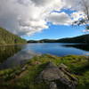
This trail is narrow in the top section. Towards the end and the lowest part of the trail, there is a rocky section, after this, the trail goes down to grass and a picnic area.
We use cookies to improve your browsing experience, to show you
personalized content, and for statistical purposes. By continuing
to navigate our website, you accept our use of cookies. Read our
Privacy Policy to learn more.


 Continue with onX Maps
 Continue with Facebook


 Particularly Special Place


0 Comments