
 Kriens Yellow (Helsana Trail)
6.0 mi 9.6 km • 931' Up 283.62 m Up • 927' Down 282.57 m Down

 Pilatus Mountain/Pilatus Kulm
4.6 mi 7.5 km • 5,191' Up 1582.16 m Up • 16' Down 4.73 m Down
Alpnach, CH
Klewenalp - Isenthal
9.0 mi 14.6 km • 1,914' Up 583.38 m Up • 4,575' Down 1394.45 m Down

 Continue with onX Maps
 Continue with Facebook


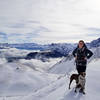
 Particularly Special Place


0 Comments