Dogs Unknown


All visitors must obtain an entrance permit to use parking areas and trailway.
Overnight campers must obtain permits at the Caprock Canyons State Park and Trailway Headquarters.
Rattlesnakes are common. Always watch where you put your hands and feet.
Description
Part of the 64-mile-long, multi-purpose trailway which offers a unique and exiting recreational experience for hikers, bikers, and equestrian trail riders. Day use permits and updated trailway information can be obtained from Caprock Canyons State Park and Trailway Headquarters, three miles South of Quitague, Tx, on FM 1065. Phone: 1(806)-455-1492.
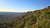
The Western-most part of the Trailway, the Quitaque Canyon Trail can be accessed from South Plains or Monk's Corssing.. A parking area is available at either end of the trail and backcountry campsites are available at John Farris Station and the Eastern side of Clarity Tunnel. Water availability at trailheads and on trail is unreliable so hikers and backpackers should plan ahead regarding water needs and pack plenty of water. The trail is open in most areas so wind and sun exposure can be concerns.
While at Clarity Tunnel:
Do not touch bats - alive or dead.
Do not make loud noises.
Do not shine lights or throw objects at bats.
Do not linger inside tunnel.
Raise as little dust as possible as you pass through the tunnel.
Wear long sleeved outerwear and hats while traveling through the tunnel.
In 1992, TPWD acquired a donation of 64.25 miles of a 1920's era railroad right-of-way stretching from the Western trailhead at South Plains atop the Caprock Escarpment to the Eastern trailhead at Estelline in the Red River Valley. The Caprock Canyons Trailway opened in 1993 as part of the national Rails-to-Trails program converting abandoned railroad right-of-way to hiking, biking, and equestrian trails. The Trailway also runs through the 742 foot long Clarity Tunnel, one of the last active railroad tunnels in Texas and home to a population of Mexican free-tailed bats.
Contacts
Shared By:
Hiking Project Staff

 Continue with onX Maps
 Continue with Facebook


 Particularly Special Place


 Intermediate


0 Comments