
 Continue with onX Maps
 Continue with Facebook


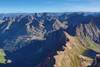
 Particularly Special Place


 Difficult

 Difficult
Land Manager: USFS - San Juan National Forest Office
 Four Mile Falls/Anderson Trail Loop
13.6 mi 21.9 km • 3,256' Up 992.56 m Up • 3,253' Down 991.49 m Down
 Pagosa…, CO
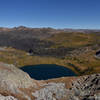
 Emerald Lake - Vallecito Creek Loop
36.9 mi 59.3 km • 5,018' Up 1529.62 m Up • 5,006' Down 1525.94 m Down
Bayfield, CO
 Sunlight and Windom
18.9 mi 30.4 km • 6,235' Up 1900.45 m Up • 6,235' Down 1900.45 m Down
Silverton, CO
Eolus Group
18.9 mi 30.5 km • 5,901' Up 1798.77 m Up • 5,901' Down 1798.77 m Down
Silverton, CO
Chicago Basin 14er Grand Slam
28.9 mi 46.5 km • 12,167' Up 3708.44 m Up • 12,167' Down 3708.44 m Down
Silverton, CO
Colorado Trail (CT)
487.3 mi 784.3 km • 83,178' Up 25352.6 m Up • 81,864' Down 24952.2 m Down
Roxboro…, CO


0 Comments