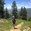
Gaining the first 600 feet with few switchbacks, the trail meets with the more popular Lily Lake Trail. Turning left, the next third of a mile steepens to gain a hump, then eases off across the second mile in a dense forest of pine and aspen. In these two miles, the trail crosses a number of seasonal snowmelt streams, as well as the creek itself more than once. Keep an eye out for the gnome who stands guard.
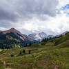
The trail veers from the creek, and the switchbacks start in. Soon, 2.6 miles in, the trail pulls into a vibrant meadow teeming with wildflowers. The creek comes and goes, and treeline nears. At 4 miles, the trail finally puts the last tree behind it in a narrow basin sitting at 11,100 feet.
In the winter, this is about as far as you would want to go. But with clear summer conditions, the trail enters the open tundra before disappearing into the fold. Heading northeast, sporadic cairns mark the route, and uphill, a faint outline can be spotted in the undergrowth. The dirt comes back, waning here and there before heading into a rocky section. With careful eyes, hikers can easily make it to the pass on the established route.
From the saddle, the views open up. To the southeast: Capital Peak, Hangerman and Snowmass Mountain (though Snowmass Peak remains barely hidden behind the two); and below you, the Avalanche Creek drainage with
Mount Sopris at the mouth almost directly to the north. Looking back the way you came, the high summits of the Raggeds rise southwest of Marble.
At the summit, find the trail as it heads downhill on a sharp ridgeline. Steep, precarious, and loose, take your time through here with slow, cautious steps. Wayfinding becomes increasingly difficult, but your aim is to reach the saddle just before the ridge climbs again, where a cairn marks the trail's turn.
If the weather permits, or if this is done as a longer undertaking with a return trip along Avalanche Creek or any of the other trails that branch off from it, turn right. The route steepens as it drops off the ridge to follow a very faint and very seldom-used trail towards an unnamed stream. Feeding into Gift Creek, the trail loses elevation fast, eventually ending at
Avalanche Creek Trail alongside its namesake.

 Continue with onX Maps
 Continue with Facebook


 Particularly Special Place


 Difficult


0 Comments