Use onX Backcountry to explore the terrain in 3D, view recent satellite imagery, and more.
Now available in onX Backcountry Mobile apps!
For more information see this post.
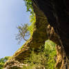
Orange trail markers designate this route. The trail begins and ends off of the Stephens Falls Trail, making a three-mile loop into the Lost Canyon. This shallow, wooded canyon was carved from the sandstone by the same stream that feeds Stephen's Falls. Along the way, it makes intersections with the Meadow Valley Trail and Goldmine Trail and can be fairly steep in some sections.
We use cookies to improve your browsing experience, to show you
personalized content, and for statistical purposes. By continuing
to navigate our website, you accept our use of cookies. Read our
Privacy Policy to learn more.

 Continue with onX Maps
 Continue with Facebook


 Particularly Special Place


 Intermediate


0 Comments