Dogs Off-leash

Features
Views · Wildflowers
Overview
A monstrous, scenic climb to one of the most prominent peaks in South Lake Tahoe.
Need to Know
Parking and finding the trail can be tricky. Come early to nab one of a few parking spots. Though this is an "unofficial" trail, it still takes you into the Desolation Wilderness where a permit is required. You can get day hike permits at the Pacific Ranger station just east of Fresh Pond on Hwy 50
Description
This unofficial trail starts just east of the creek that flows under Route 50. Look for a path up a steep embankment on the north side of the road. Trail starts a little east of parking area and is a little hard see as there is no trail marker. Look for areas where others have scrambled up the embankment 10 feet or so.
Once you've found the right trail, it will be wide and clear - and remain that way until the summit. The trail is surprisingly steep and unrelenting. There are few to no water sources beyond about the 2 mile mark...it is a steep, exposed and arduous hike as you approach the summit...bring plenty of water!
The last few hundred feet of climbing are a hands-and-feet scramble up a jumbled pile of granite boulders.
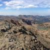
The summit offers excellent views of the Crystal Range and Lake Aloha In the heart of the Desolation Wilderness. Once you've admired the views, return to your vehicle by heading down the way that you came.
Flora & Fauna
Ponderosa pine, incense cedar, sugar pine, and white fir thrive at lower elevations. Mountain hemlock, western white pine, lodgepole pine, red fir, and aspen dot the hills higher up. Whitebark pine are found below the summit.
Contacts
Shared By:
Miguel Vieira
with improvements
by Larry Greene

 Continue with onX Maps
 Continue with Facebook


 Particularly Special Place


 Difficult

 4.8 (28)


1 Comment