
 Continue with onX Maps
 Continue with Facebook


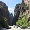
 Particularly Special Place


 Very Difficult
Very Difficult
Very Difficult
 Very Difficult
 Long Draw (Gulch)
1.8 mi 2.9 km • 1,422' Up 433.33 m Up • 1,422' Down 433.34 m Down
 Montrose, CO
 Red Rock Canyon Route
6.5 mi 10.4 km • 1,320' Up 402.37 m Up • 1,319' Down 402.13 m Down
 Dillon Pinnacles Trail Out and Back
3.9 mi 6.4 km • 433' Up 131.95 m Up • 433' Down 132.1 m Down
Alpine Trail- Silver Jack Segment
10.8 mi 17.4 km • 2,488' Up 758.35 m Up • 2,487' Down 758.18 m Down
 Ridgway, CO
Dark Canyon Trail Point to Point
Ridgway, CO
Dark Canyon Trail Point to Point
14.6 mi 23.6 km • 1,581' Up 482.01 m Up • 3,661' Down 1115.78 m Down
Crested…, CO
Flowing Park Loop
14.9 mi 24.0 km • 527' Up 160.64 m Up • 525' Down 160.17 m Down
Cedaredge, CO


2 Comments