Well designed trails with technical rocks make up this great SLO route. Along the way, hikers can expect to take in some sun while enjoying the trails.
From the trailhead at Johnson Ranch, start counter-clockwise, heading north on the
South Loop. Work your way up the hill, through a cattle gate and transition to the
North Loop. From here, you'll first head back down, then start climbing again. The Johnson Ranch trails are well designed and used often.
Follow the
North Loop up into a shaded canyon. When the trail turns hard left, take a right over the cattle guard. This is the
Filipponi Trail. Follow this up the south slope of a hill past a stand of oaks to a left turn and a bench. Up this doubletrack on the north slope. At the back of this drainage, the road/trail will make a hard right and continue on a contour. The trail breaks left up the south slope. This part of the trail is a steady climb with rocks and rolling grade changes that make it a fun challenge to move quickly. At the ridge the trail turns hard left for more technical rocks down the slope. The trail merges with a dirt road. Go Left. At the power line tower, look for a trail on the left.
This is the Pond Loop, though it may have been renamed "Wednesday". Follow this trail up more technical, steady climbing rocky fun. Stacked on top of the Pond Loop is the Miner's Loop, and finally the
Ocean View Trail. At this time the
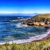
Ocean View Trail is an out and back. At the ridge you can look down the Los Osos Valley to the ocean and have great views of the peaks on the other side of the valley.
Head back down the
Ocean View Trail, continue clockwise around the Miner's Loop. There is evidence of some rock mining in this area.
Heading clockwise around the Pond Loop will bring you past a pond with a concrete dam. Continue below the dam. Eventually, there will be a shade tree, bridge and bench. There is water in the spring. Keep going around the loop and you end up back on the Nameless Road Bypass at the next power line tower west.
The road is at the back of a drainage. Turn right on the road, and veer left at the fork (right will close the Pond Loop). The Nameless Road Bypass will leave the road on the left and climb for a bit before switching back and descending. Around the north side of the hill there are "flying switchbacks", bridges to complete the switchbacks on the steep slope. Follow this down past four flying switchbacks, and you'll end up on the same road again.
Turn hard left and you'll find the Neil Hawk Way that descends the north slope to Froom Creek. Rocks and rolling grade changes make this trail fun as well. At the Creek continue to the Irish Hills up the other side. I turned back, repeated the flying switchbacks and skipped the Pond Loop by staying on the road.
Watch for the
Filipponi Trail on the right, then head back to Johnson Ranch. At the cattle guard stay right and follow the trail that maintains elevation somewhat, in and out of the oaks. It will turn north then switchback down a steep hill with a couple sycamore trees and bridges, then down to a creek. Up the other side of the creek and you'll cross a road. Stay on the trail, and up a climb and into some oaks before a fast section heading east back down to the Johnson Ranch trailhead.

 Continue with onX Maps
 Continue with Facebook


 Particularly Special Place


 Intermediate

 Bishop Peak Trail

 San Lui…, CA
 Bluff - Oats Peak Loop


0 Comments