Dogs Off-leash

Features
River/Creek · Views
Overview
This is a great trail for dog lovers as you can let your dog off leash to romp alongside you while you hike. There are many water crossings to cool you and your buddy down on a warm day.
Need to Know
There is a bathroom at the trailhead parking lot, but there are no trash cans or doggy poop bags, so bring your own bags and be prepared to haul your trash out. There are many water crossings in the first 2 and final 3 miles, but otherwise the trail is all pretty exposed to the sun and there is no water between mile 2 and 5ish. Dogs are allowed off leash here, making it a fun place to hike with your dog, just be aware of the lack of creek water between miles 2 and 5 on a warm, sunny day. There is no drinking water available at the trailhead.
Description
The lollipop-shaped trail begins on a slight downhill, but then begins a very gradual incline over the first 2 miles with many water crossings. When you reach a split in the trail just past the 2-mile mark, go left for a one-mile climb with several switchbacks.
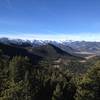
After reaching the 3-mile point, the trail becomes a little more rolling, with some dips down and short steep climbs back up. You'll eventually top out around 6,850 feet of elevation before beginning the gradual descent through wide open grassy fields.
Around the 5-mile mark, you'll find more water crossings as you follow the creek back through the burned out forest to complete the loop section of the trail. You'll complete the loop around mile 6, where you'll begin a gradual descent back to the trailhead.
Flora & Fauna
There was a huge fire here in 2012, so there are many burned and fallen trees. We have seen deer and bighorn sheep in the area and signs of moose.
History & Background
You'll see some remains of homesteads from the early 1900s in the first 2 miles of the trail.
Contacts
Shared By:
Deborah Gulley

 Continue with onX Maps
 Continue with Facebook


 Particularly Special Place


 Intermediate

 4.3 (31)


 All Clear


0 Comments