Dogs Leashed

Features
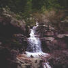
Waterfall
Description
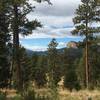
The trailhead is easily visible from the parking lot. From the lower trailhead, follow the well-worn trail. After about 0.8 miles of moving through a forested area another trail will branch out. This other trail will not have a sign, so don't make the mistake of following it! The Maxwell Falls Trail will have a sign denoting the direction of the trail. Follow the signed trail through the forest until you reach a small foot bridge crossing the Maxwell Creek. This crossing is a little over a mile from the trailhead.
After crossing the bridge the trail will split in two directions. The trail to your right is one end of the
Cliff Loop Trail. Take the trail to your left which is the Maxwell Falls Trail. This part of the trail will take you along the creek and you'll pass along the bottom of a large cliff face. Continue another half a mile along the Maxwell Falls Trail, and the trail will branch off again.
From this point you should be able to hear the Maxwell Falls -- follow the sound to see the falls. The falls are seasonal so if you are exploring the area later in the summer season (or in late fall or winter) you'll be less likely to hear the falls.
The short connector trail to your left will continue to the upper trailhead, completing the trail.
Contacts
Shared By:
Danielle Jackson

 Continue with onX Maps
 Continue with Facebook


 Particularly Special Place


 Intermediate

 4.3 (14)


0 Comments