
 Continue with onX Maps
 Continue with Facebook


 Particularly Special Place


 Difficult
Difficult
Difficult
 Difficult
Land Manager: NPS - Shenandoah National Park
 Blackrock Summit Loop
1.2 mi 1.9 km • 219' Up 66.62 m Up • 206' Down 62.86 m Down

 Grottoes, VA
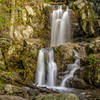
 Upper Doyles Falls
3.1 mi 5.0 km • 954' Up 290.65 m Up • 959' Down 292.22 m Down
Frazier Discovery Trail
1.3 mi 2.1 km • 420' Up 128.05 m Up • 420' Down 128.04 m Down
Trayfoot/Blackrock Mountain Loop
10.3 mi 16.5 km • 2,075' Up 632.59 m Up • 2,077' Down 633.14 m Down
Crimora, VA
South River Falls
4.6 mi 7.4 km • 1,165' Up 355.09 m Up • 1,165' Down 355.19 m Down
Ragged Mountain Reservoir Trail
6.9 mi 11.0 km • 1,142' Up 348.03 m Up • 1,142' Down 347.93 m Down
Charlot…, VA


 All Clear


0 Comments